Japan’s Seismic Activity: Notable Earthquakes Since 2011
In the aftermath of the Great East Japan Earthquake disaster on March 11, 2011, Japan has experienced over 30 significant earthquakes, registering at a seismic intensity scale of lower 6 or higher over the years.
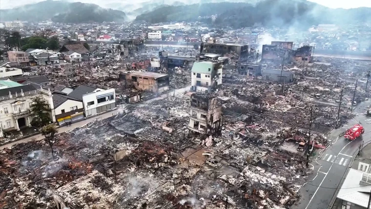
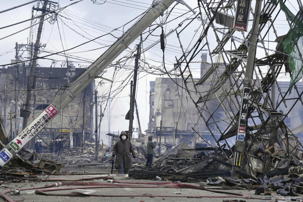
On the afternoon of January 1, 2024, precisely at 4:10 PM, an earthquake originating from the Noto Peninsula in Ishikawa Prefecture occurred, resulting in seismic activity reaching level 7 on the Japanese seismic intensity scale in the town of Shika. The Japan Meteorological Agency promptly revealed that the earthquake had a shallow hypocenter and an estimated magnitude of 7.6. Subsequently, tsunami waves measuring 1.2 meters were observed at Wajima, leading to the issuance of a significant tsunami warning for the Noto Peninsula.
Earthquakes of Lower 6 Intensity or Above Since the Great East Japan Earthquake
| Date (Time) | Hypocenter | Magnitude | Seismic Intensity |
| January 1, 2024 (16:10) | Noto Peninsula, Ishikawa Prefecture | 7.6 | 7 |
| May 5, 2023 (14:42) | Noto Peninsula, Ishikawa Prefecture | 6.5 | Upper 6 |
| June 19, 2022 (15:08) | Noto Peninsula, Ishikawa Prefecture | 5.2 | Lower 6 |
| March 16, 2022 (23:36) | Off Fukushima Prefecture | 7.3 | Upper 6 |
| Feb 13, 2021 (23:07) | Off Fukushima Prefecture | 7.3 | Upper 6 |
| June 18, 2019 (22:22) | Off Yamagata Prefecture | 6.7 | Upper 6 |
| Feb 21, 2019 (21:22) | Central/eastern Iburi, Hokkaidō | 5.8 | Lower 6 |
| Jan 3, 2019 (18:10) | Kumamoto, Kumamoto Prefecture | 5.1 | Lower 6 |
| Sep 6, 2018 (3:07) | Central/eastern Iburi, Hokkaidō | 6.7 | 7 |
| June 18, 2018 (7:58) | Northern Osaka Prefecture | 6.1 | Lower 6 |
| Dec 28, 2016 (21:38) | Northern Ibaraki Prefecture | 6.3 | Lower 6 |
| Oct 21, 2016 (14:07) | Central Tottori Prefecture | 6.6 | Lower 6 |
| June 16, 2016 (14:21) | Uchiura Bay, off southwestern Hokkaidō | 5.3 | Lower 6 |
| April 16, 2016 (9:48) | Kumamoto, Kumamoto Prefecture | 5.4 | Lower 6 |
| April 16, 2016 (3:55) | Aso, Kumamoto Prefecture | 5.8 | Upper 6 |
| April 16, 2016 (1:45) | Kumamoto, Kumamoto Prefecture | 5.9 | Lower 6 |
| April 16, 2016 (1:25) | Kumamoto, Kumamoto Prefecture | 7.3 | 7 |
| April 15, 2016 (3:46) | Kumamoto, Kumamoto Prefecture | 6.4 | Upper 6 |
| April 14, 2016 (22:07) | Kumamoto, Kumamoto Prefecture | 5.8 | Lower 6 |
| April 14, 2016 (21:26) | Kumamoto, Kumamoto Prefecture | 6.5 | 7 |
| Nov 22, 2014 (22:08) | Northern Nagano Prefecture | 6.7 | Lower 6 |
| April 13, 2013 (5:33) | Near Awajishima, Hyōgo Prefecture | 6.3 | Lower 6 |
| April 12, 2011 (14:07) | Central Fukushima Prefecture | 6.4 | Lower 6 |
| April 11, 2011 (17:16) | Eastern Fukushima Prefecture | 7.0 | Lower 6 |
| April 7, 2011 (23:32) | Off Miyagi Prefecture | 7.2 | Upper 6 |
| March 15, 2011 (22:31) | Eastern Shizuoka Prefecture | 6.4 | Upper 6 |
| March 12, 2011 (5:42) | Northern Nagano Prefecture | 5.3 | Lower 6 |
| March 12, 2011 (4:31) | Northern Nagano Prefecture | 5.9 | Lower 6 |
| March 12, 2011 (3:59) | Northern Nagano Prefecture | 6.7 | Upper 6 |
| March 11, 2011 (15:15) | Off Ibaraki Prefecture | 7.6 | Upper 6 |
| March 11, 2011 (14:46) | Off Sanriku area | 9.0 | 7 |
(Originally released in Japanese. Header image: Damage to the Tōhoku Expressway between the Kunimi and Shiroishi Interchanges resulting from the earthquake on March 16, 2022. Photo captured in Shiroishi, Miyagi Prefecture, on March 17, 2022. Courtesy of East Nippon Expressway Company; © Jiji.)